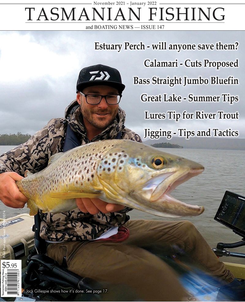
Arthurs Lake - a trouting smorgasbord
Arthurs Lake has, for many years been one of Tasmania's premium trout fisheries. This profile of the Arthurs Lake has been made possible with thanks to Rob Sloane and Greg French for information from their book "˜Trout Guide"plus trout guide - John Fox and Inland Fisheries Commissioner - Wayne Fulton.
Arthurs Lake is on the eastern side of the Poatina Highway (B51). 5 km north of the Lake Highway (A5) intersection. The lake is approximately 95 km from Launceston via the Poatina Highway and 125 km from Hobart (54 km from Bothwell) via the Lake Highway, giving convenient, scaled road access from the two major population centres.
Description
Arthurs Lake is a large 6460 ha hydro-electric storage which was created by damming the Upper Lake River in 1961. Originally the Lake River drained two separate lakes - these being the Blue Lake in the West and the Sand Lake in the East. These lakes varied by 3.5 metres in elevation and after the winter of 1963 they began to rise as one lake (from 946 metres) in early 1964. The Full Supply Level of the new lake was a rise of 10 metres over the original lover lake's level.
Arthurs Lake receives water from its natural catchments and discharges into Great Lake via a pump and pipeline. This pumping of water into Great Lake commenced in 1966. It is pumped uphill from Arthurs Lake then via approximately 6 km of fluming to Great Lake. The fall into Great Lake is used to power a small turbine which is in turn used to operate the pump at Arthurs Lake. The average yearly input to Great Lake is about 3.7 cumecs. Occasional water releases are directed to Woods Lake via the Upper Lake River.
The water in Arthurs Lake is generally noted for its clarity and there are thick beds of Canadian pond weed and dense stands of drowned timber in many places. Lake level can vary to the extent of 9 metres, though changes in level are seasonal rather than sudden. Full supply level is approximately 952 metres above sea level and the NMOL was 943m.
HEC Agreement
In 1993 the HEC agreed to raise the NMOL 5 metres to 948 m. This is 1.5 metres above the recorded low levels of 1991 and 1992 which saw the Cow paddock area dry. Good rains throughout 1996 have since filled the lake to near capacity with a current level of 1.2 metres from FSL.
Accommodation
The nearest accommodation is the Compleat Angler Lodge at Great Lake, which is approximately 20 km from Pump House Bay via the Poatina and Lake highways. The Great Lake Hotel is a further 2 km, at the Marlborough Highway intersection. Accommodation is also available at the Poatina Chalet which is 36 km north, at the foot of the Great Western Tiers, via the Poatina Highway.
Camping
A formal camping ground, offering caravan sites(power is not available), showers, toilets, water, camping areas and day use picnic facilities, is located at Pump House Bay, just off the Poatina Highway. Another camping ground is further north at Jonah Bay. The turn off to Jonah Bay is about 4 km north along the Poatina Highway from Pump House Bay. Both camping areas at Arthurs Lake are controlled by the Department of Parks, Wildlife and Heritage and further information is available from the Departments base at Liawenee, Great Lake. Use of these areas is encouraged through informal camping occurs in many places around the lake.
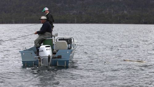
Boating
Arthurs Lake owes much of its popularity to boat fishing and there are three major boat ramps servicing this extensive water. The most easily reached is the launching area by the Pump Station at Pump House Bay, just off the Poatina Highway. A second ramp and parking area is located at Arthurs Dam, 9 km from the Poatina Highway via Arthurs Lake Road (C525). This is a concrete ramp which offers the deepest water for launching large boats. A further boat launching ramp and parking area is at Jonah Bay. This is suited to smaller boats and eliminates the need to cross the open waters of the lake in order to fish the productive Cow paddock Dam.
The lake has claimed a disturbing number of lives and extreme caution is urged when boating. The weather can change rapidly, causing a sudden build up of waves. There are many unmarked, submerged rock and tree-stump hazards.
Regulations
Arthurs Lake is open to all methods including bait fishing. All streams flowing into Arthurs are closed to fishing at all times, as is a 50 metre radius around each inflow.
Trout Stocks
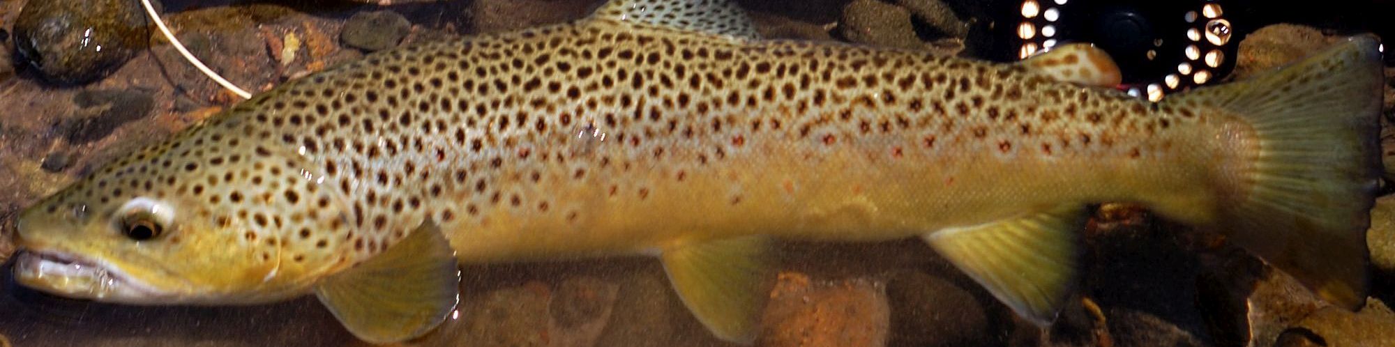
Arthurs Lake is a wild brown trout fishery supported entirely by natural recruitment. Streams in the natural catchment of the lake provide more than adequate stocks. Arthurs has a reputation as the most productive Brown Trout fishery in the State.
Trout of 0.4 - 1.4 kg can be expected but quality and size vary from year to year depending on lake levels and climatic influences on spawning success and recruitment. Over the last couple of years the size of trout has shown general increase. This has been consistent with the higher and less variable lake level.
Angling Statistics
Arthurs Lake is the most popular fishery in Tasmania. Annual harvest is the highest of any local water at around 125 000 trout and it is estimated that some 10 000 anglers visit this water each season. Catch rate is a very healthy 2.4 trout per angler per day.
Historical Notes
The modern Arthurs Lake inundated to natural lakes, Sand Lake and Blue Lake (Arthurs Lake), and a marsh known as the Morass. The original lakes may have been stocked with brown trout in 1870, at the same time as a number of other unspecified lakes in the highlands, but this is difficult to substantiate. It is recorded that 500 rainbow trout fry were liberated in the "Upper Arthurs Lake" during the 1904 - 05 season and that by 1915 more than 35 000 rainbow fry and 2500 rainbow yearlings had been turned out.
The "˜Upper"lake also received consignments of 200 Atlantic salmon in 1907 - 08 and over 2000 Sebago salmon (a landlocked strain) in 1910 - 11. During early stocking experiments the Upper Arthurs Lake was closed to fishing and it was "˜thrown open to angling"on February 1913.
Between 1913 and 1915 "˜fair sport"was enjoyed at the lake. Rainbow trout dominated but a few salmon were taken as well, though there were no reports of brown trout being caught. At this time reading was poor but access could be made via Interlaken from the Midlands and via Bothwell from the south.
By 1922 - 23 a small temporary dam had been completed on the Upper Lake River. Its purpose was to store and regulate water flow, in conjunction with another dam at Woods Lake, thus assisting the operation of the power station at Ducks Reach near Launceston. The Northern Tasmanian Fisheries Association report for 1934 recorded that both rainbow trout and Loch Leven strain brown trout were present in Arthurs.
During the 1946 - 47 season 150 000 brown trout fry were released. By the early 1950s the area has gained considerable popularity and the terms "˜Blue Lake"(for the western storage) and "˜Sand Lake"(for the Upper Arthur Lake) had been adopted.
At about this time the trout in Blue Lake averaged 2 - 3 lb whereas those in Sand Lake were reported to be a little smaller.
Both lakes were relatively free of weed and snags, and trolling gained popularity. Indeed, one writer described Blue Lake in the summer of 1957 as resembling "˜a miniature Regatta'. Reports of the 1950s offer the first good descriptions of the Morass, the marshland lying between the outflow of Sand Lake and the inflow of Blue Lake. This area was swampy ad laced with channels and lagoons. It held much bigger trout and some exceptional fly fishing was reported.
In 1954 Arthurs was described as "˜perhaps the 3rd best lake fishing water in Tasmania"and it was reported that, "˜many thousands of fish were taken last year'. By 1956 the trout population consisted of "˜mostly brown"¦"¦with a very occasional rainbow'. Throughout the latter half of the decade thousands of brown trout fingerlings were released, mainly in the Morass. After this time there were no significant records of rainbow trout captures.
In the early 1960s the Hydro - Electric Commission upgraded roads into the area and by 1964 the small dam at the outflow of Blue Lake had been superseded by a new 15 metre high structure. By the winter of 1965 Arthurs Lake had "˜almost become one complete lake'. During the 1964 - 65 season most trout taken were about 1 kg, although a good number of 3 kg were reported from the Morass area. In the following year the average weight had risen to about 2.7 kg and browns to 3.5 kg were common. But the boom was short lived. Some reports suggest that the average size of the trout dropped from about 2.3 kg in the pre-Christmas period of 1967 to about 1.4 kg post-Christmas. In June 1968 the average weight of spawning fish was only 0.7 kg.
Features
The Pumping Station and boat launching area are the conspicuous features of Pump House Bay. Access is directly off the Poatina Highway at the pipeline. The bay extends around in front of the Flintstone Drive shack settlement and the shore is essentially gently - sloping and grassy.
When the water level in Arthurs Lake is high, trout move into the grassy edges and good bags are taken on bait and fly. Numerous shallow gutters around the bay are not spots and trout tail along the edges in the early mornings. Wading is straight forward when levels are high, but when the lake is down, much of the bay becomes muddy and unattractive. The deep cut in front of the Pumping Station is a noteworthy fishing hole. Trout are attracted around the outlet when the station is running and this is when fishing is best. All methods can take fish here.
Some exceptional trophy trout have been caught in the immediate vicinity. These big trout feed mainly on fish guts discarded at the boat ramp and this accounts for their extraordinary size. The shore around the southern point of Pump House Bay features heavy stands of dead timber and this limits shore fishing, though trout can be taken from the bank by fishing the gaps between the trees.
The outer perimeter of the trees is a reliable trolling beat and trout are also taken by lure casting and fly fishing from drifting boats. The area is reasonably protected from westerly and southerly winds. Just around the point from Pump House Bay, Creely Bay provides excellent fishing in open water between stands of dead trees. This sheltered corner is reached by boat from Pump House Bay or from Arthurs Dam.
At high lake levels the wet fly can be fished in the grassy margins. Creely Bay also boasts reliable summer mayfly hatches and exceptional dry fly fishing from a moored or drifting boat. Further south Teatree Bay is accessed directly from Arthurs Lake Road in front of the shack settlement. This is a popular bait fishing shore which also hold reasonable fly fishing water at high lake levels.
The main creek-drains in the bay should be given special attention. Trees on either side limit shore fishing, though boat fishing along the outside is worthwhile. Teatree Bay is one of the most sheltered shores on Arthurs Lake in southerly winds, but is very exposed to northerlies. Snake Point is the prominent rocky point between Teatree Bay and Arthurs Dam. The rocky shore from the point to the dam features deep water and is popular for set - rod night fishing and daytime lure casting. This bank is suitable for dry fly fishing in warm settled weather when beetles are on the wing.
Arthurs Dam is 9 km from the Poatina Highway via Arthurs Lake Road and has the most sheltered and best deep water launching ramp, especially in strong south westerly winds.
The south eastern Morass Bay beyond the dam gains its name from the Morass marshland which was originally located in this basin. The open waters of Morass Bay are a noted trolling ground which consistently yields the best quality trout in the lake, as did the original Morass. Presumably the lake bed still supports rich feeding beds in this area. Arthurs Lake Road deteriorates rapidly past the Yangena shacks and much of the Eastern Shore receives only limited attention from anglers, due mainly to its exposed aspect and dense stands of drowned trees. A rough four-wheel-drive track continues right around to the northern end of the lake but most anglers access the Eastern Shore by boat from Arthurs Dam. Fishing this shore is limited to periods of relatively settled easterly weather and good dry fly fishing can be found at such times.
O'Connors Corner and the Subsidiary Dam are quite popular, particularly with bait fishers. The north eastern bays of Arthurs Lake flood grassy flats in the Lawrence Plain area. Flemings Bay is the largest of these and has an extensive area of grassy shallows when lake levels are high. The bay is still very exposed to southerlies and westerlies but does provide some shelter from moderate northerly winds. Fleming Bay is an excellent fly fishing area though it receives limited attentions. Highlands are early season wet fly fishing when the lake is up, and prolific dun hatches on settled days during the summer months. Sand Lake Bay offers similar, though more restricted fishing. The north eastern corner of the take is the most isolated as it cannot be readily accessed by vehicle, and by boat is about 9 km from Arthurs Dam across open and exposed water.
Jones Rivulet flows into Arthurs Lake from Little Lake which lies to the north east. The stream discharges into Jones Bay. This corner is quite sheltered, being protected from northerly and to some extent westerly winds. The bed of the stream is a distinctive feature and always holds numerous trout, but remember that Jones Rivulet itself is closed to fishing at all times. Drift - spinning among the drowned trees over the river bed is particularly effective. The fly fisher can expect to find trout in the flooded edged early in the season, and dun and caddis hatches for summer dry fly fishing. Again, Jones Bay is quite isolated and not heavily fished. The area can be accessed by boat from Jonah Bay via Camerons Opening at high lake levels.
The major point between Jones Bay and Tumbledown Bay is known as Cormorant Point. The foreshore is rocky and lined with drowned timber which provides a noted cormorant roost. Excellent drift - spinning can be found over the deeper water outside the trees and this area is nicely sheltered in northerly weather. Tumbledown Creek is one of the major spawning tributaries of Arthurs Lake and trout gather off the creek mouth late in the season in preparation for spawning.
Drowned trees lining the shore restrict fishing in Tumbledown Bay through lure and fly fishing from a drifting boat can be rewarding, especially early and late in the season. Anglers usually concentrate their efforts over the deeper channels and holes associated with the flooded creek bed.
A solid four- wheel drive track extends from the Cow paddock Bay road to Tumbledown Creek before heading away from the Lake en route to Gunns Lake. Otherwise Tumbledown Bay is reached by boat from Jonah Bay via Camerons Opening when water levels are high. The major promontory between Tumbledown Bay and Sevenpound Bay is known as Passage Point. On the Tumbledown side the shore is relatively deep and timbered, whereas to the west the water is quite shallow and open.
The deeper Tumbledown side is sheltered in westerly weather and more suited to lure casting, though at times the point also produces excellent dry fly fishing during mayfly hatches. Duns hatch in the shallow water on the western side and blow across the point over the deeper water. South of Passage Point, Camerons Opening creates a passage between the shallow Cow paddock arm to the west and the deeper waters of the original Sand Lake basin to the east. This opening is shallow and can only be negotiated by small dinghies at high lake levels. Large boulders and rock out crops dot the passage and extreme care is needed in making the crossing.
When the lake falls, a land bridge forms across the opening, joining with Hawks Island. The shallows across Camerons Opening support large numbers of trout, provided Arthurs isn't too low. The area is best fished from a drifting boat and is readily accessed from the Jonah Bay launching ramp. Spinning and wet fly fishing account for the bulk of the catch in the spring and autumn months, whereas excellent dun hatches favour dry fly and nymph fishing in the summer.
The shallow bank between Camerons Opening and Hawk Island features several rocky island outcrops, as well as deeper areas distinguished by strap weed growth. The rich weedy hollows are known as the Lily Ponds and are essentially flooded ponds which can be recognised as water levels recede. This general area is one of the most productive fishing grounds on Arthurs Lake. In northerly winds or light westerly breezes it is a perfect fly fishing environment and features very heavy dun hatches during the summer months. Sevenpound Bay, just outside the transmission lines between Camerons Opening and Cow paddock Bay, is another favourite location.
Light westerly and light to moderate northerly winds favour this bay. Here the weedy shallows offer useful early-season wet fly fishing and reliable summer mayfly hatches. Drift spinning is very effective, particularly in slightly rougher conditions, and trolling the mouth of the bay is included in the popular circuit north of Jonah Bay.
Cow paddock Bay has long held a reputation as the most productive water on Arthurs Lake. Road works have extended car access as far as Scotch Bobs Creek, two thirds of the way along the western shore of the Cow paddock, and the boat ramp at Jonah Bay has provided quick and safe access to the area for boat users. From the overhead transmission lines which cross the lake at the mouth of the bay, the Cow paddock extends 3 km north at full supply level and this arm of the lake is shallow, weedy and rich in trout food.
At low levels much of the bay becomes unfishable and anglers turn their attention to the deeper areas around the mouth. Cow paddock Bay is quite sheltered in most conditions though a strong northerly, straight down the bay, can make things difficult. When Arthurs Lake fills, the Cow paddock shores flood across grassy flats, more particularly on the western side and at the northern extremity. At such times trout feed freely in the shallows and the wet fly fishing can be exceptional. Bait fishing with worms can also yield heavy bags when the lake is full, and the point just north of the transmission line is a popular camping and bait fishing area. As the water begins to recede, tailing fish are often evident over the shallow weedy mounds and along the edges.
By early November heavy dun hatches become the main attraction and the dry fly fishing is only rivalled by Little Pine Lagoon. Prolific caddis and midge hatches are also a feature of the Cow paddock. When fishing from the shore, deep wading is often necessary to reach rising trout for the reason many prefer to fish the dry fly from an anchored or slow drifting boat.
Traditional loch style wet fly fishing is also successful here and wet flies and nymphs account for the overall majority of fish taken. Lure casting from a boat can be equally effective, especially over the deeper holes and around the patches of sticks and trees near the mouth of the bay. Three significant spawning streams feed Cow paddock Bay: Scotch Bobs Creek, Buchanan Creek and Cow paddock Creek.
Trout congregate off these early and late in the season, particularly if recent rain has resulted in a steady water flow. The flooded creek channels and associated ditches, drains and holes create holding areas and pathways for the trout. These are the areas to target when trout are not rising or showing in the shallows. Take note that fishing is prohibited within a 50 metre radius of the inflows. Transmission Line Bay, immediately south of the transmission lines at the mouth of Cow paddock Bay, provide a very good shore for fly fishing.
At high water levels the bay extends back behind an isolated island. The shallow weedy water behind the island provides ideal fly fishing water. This is as good a bay as any readily accessible by car, though you need to be prepared to wade deep to get to the best of the mayfly fishing.
The transmission lines essentially demarcate the mouth of Cow paddock Bay, and trolling, spinning and fly fishing account for heavy bags of trout in this area. Drifting the open waters beneath the transmission lines is common practice when lake levels are sufficiently high, and casting a lure around the flooded sticks and trees in this area is a sure bet.
Jonah Bay itself is shallow and grassy when the lake is high and at such times it is a useful wet fly area. When water levels are low the shoreline is less attractive, though trout are still taken here. The Jonah Bay shore has the advantage of being sheltered in westerly winds. The deeper points to the north and south provide bait fishing vantages wherever the flooded timber permits.
Lure casting, trolling and fly fishing from boats are all common in the general area between Jonah Bay and Hawk Island, though it should be noted that the open water is scattered with hidden stumps and rocks. The shoreline south of Jonah Bay is steeper, more rocky and lined with drowned trees. The trees extend well out into the lake off Rocky Point. A feature of this area is the afternoon rise to black spinners, on still days during the mayfly season.
Whilst shore fishing is limited, fishable gaps are scattered among the trees. Trolling in the deeper water outside the tree-line does produce fish though lure casting between the trees from a drifting boat is a more effective way to fish this water. When trout aren't showing on the surface, wet fly fishing with a sinking line around the outer trees is always worth a try. The shore west of Rocky Point shallows off into Phantom Bay, though this area is still shrouded in drowned trees.
Phantom Bay especially opens out behind the tree-line and provides open water close to shore. This corner has the advantage of being sheltered from northerly winds and the surrounding trees enhance the protection. Being grassy and shallow, Phantom Bay is especially suited to fly fishing. This area is normally accessed by boat from Pump House Bay and is fished by anchoring or slow-drifting.
A great attraction of Phantom Bay is sheltered dry fly fishing among the trees. Warm afternoons see the trout leaping to mayfly spinners, and midges and caddis create rises early and late in the day. The observant angler can also Polaroid trout along the edge, among the trees. The deeper waters around the tree fringes outside the bay cater for trolling and drift-fishing with fly or lure. Before the advert of the upgraded Cow paddock- Jonah Bay access road, Hydro Bay was probably the most popular stretch of water on Arthurs Lake, especially when strong northerly winds limited boat access to the Cow paddock arm.
Hydro Bay is still the best bet on Arthurs in a northerly blow. It is generally reached by boat from the Pump House Bay launching ramp, though some anglers walk and others take four-wheel-drives along the transmission line track from Pump House Bay or from the Cow paddock road. Trout move into the shallows in Hydro Bay if water levels are sufficiently high early in the season. Wet fly fishing among the flooded tussocks and bushes can be fast and furious when conditions are appropriate. Tailing fish are a feature of the grassy flats at first light.
Hydro Bay is also noted for its dun hatches though morning midge rises and evening caddis hatches can also be worthwhile. Wet fly fishing or lure casting from a drifting boat account for more trout when conditions are a little rougher. A line of flooded trees and bushes marks the creek bed and the deeper holes in this area are always worth concentrated effort. Hydro Creek is an important spawning stream and after rain, trout gather off the creek mouth prior to spawning. This bay is always a good bet during April. Note that fishing is not permitted within 50 metres of the inflow. Bait fishing is quite popular, especially further along towards the Pump House Bay camping area. Worms are an excellent bait when the lake is rising after heavy rain.
The Islands
Arthurs Lake also features a number of extensive islands which rank highly among preferred fishing areas, though they are of limited interest to the shore angler. Interestingly, all the major islands join up when Arthurs Lake is very low and can be reached on foot across Camerons Opening. Four-wheel-drive vehicles are even driven across at times.
The Northern Hawk Island is just off Jonah Bay and both sides of the island are fished quite heavily, depending on wind direction. Brazendale Island of Rocky Point is the largest of the Arthurs Lake islands, being nearly 3 km long. Again the eastern and western shores are popular trolling, lure casting and fly fishing areas. Brazendale is generally reached by boat from Jonah Bay or Pump House Bay.
Neil Island and the smaller Jenkins Island to the south are normally accessed by boat from Arthurs Dam. The waters around these islands are popular trolling grounds, though Neil Island also provides sheltered water for fly fishing. Both islands have their regular devotees. Collectively the islands offer a variety of fishing water from grassy bays to rocky banks and extensive areas of drowned timber. Generally the deeper water is good for lure casting and trolling, whereas the shallower bays are more suited to wet and dry fly fishing.
Wind lane fishing
Worthwhile wind lanes form between the islands and these can be exploited for early morning midge fishing and evening dry fly fishing. Some anglers prefer to reach the islands by boat and then to fish from the shore. Walking across the larger islands can save a considerable boat trip in getting to the other side. Bait fishers sometimes camp out overnight on the islands. Though quite popular the islands do provide an opportunity to escape the pressures of the more accessible shores. A word of warning. Boating around the islands is quite dangerous. There are many hidden hazards and strong winds and heavy waves can build up in a matter of hours. These exposed waters are not suitable for small dinghies.
Best bets
Arthurs Lake offers a realistic chance for an inexperienced angler to catch a trout in the Central Highlands. All methods account for large numbers of modest to good size trout, though the very best of the fishing is really dependant on the use of a suitable boat.
Fly Fishing
Shore-based wet fly fishing is at its best early in the season, from September to November, when trout tail along the grassy edges, though wet fly fishing from a drifting boat produces consistent bags right through the season. Popular patterns include the Woolly Worm, Robin, Red and Black Matuka, Yeti, Rabbit Fur Fly, Mrs Simpson and a variety of traditional English wet flies including the Watson's Fancy, Mallard and Claret, Teal and Black and Wickham's Fancy. A small dropper-fly (size 10-12) is often used in conjunction with a larger wet fly(size 8) when fishing "˜blind'.
Traditional British boat-fishing methods work well on Arthurs Lake, including the "˜loch-style"technique. Two flies are cast out in front of the drifting boat and worked back, with the dropper fly being teased along the surface right up to the boat.
Similarly, the traditional Northampton style sinking line technique is also effective, with the fly being cast out across the wind and allowed to swing round as the boat drifts. Sinking lines are employed in the deeper waters of the lake, particularly early and late in the season when trout aren't feeding near the surface during the day. A large parachute-style collapsible drogue is essential for effective fly fishing from a boat on Arthurs. Don't be without one.
For the shore-based angler, chest waders are essential. The best fishing is from Jonah Bay to Cow paddock Bay and from Pump House Bay to Hydro Bay; the boat angler can add Phantom Bay, Seven pound Bay, Camerons Opening and Lily ponds. These are all noted for consistent and prolific dun hatches from early November through the summer months, usually starting three to four weeks earlier than those at Little Pine Lagoon. Nymphs, floating nymphs and may fly patterns are needed. The best nymphs include the Brown Nymph, Hare's Ear, and Pheasant Tail (size 8-10; the best dries include the Highland Dun, March Brown, Parachute Dun, Rob's Dry, Greenwell's Glory and Black Spinner (size 10-14). Dun hatches commonly peak after 11 a.m. though it pays to be on the water at least an hour before.
Hatches can occur as late as 3 or 4 p.m. if the weather moderates late in the day. Warm, slightly overcast conditions, or sunny days with intermittent cloud, produce the best rises. Arthurs Lake is also perfect for "˜dapping"from a boat with a blow line and bushy fly, through few locals practise this method.
On very bright days the rise can be quite disappointing and better results can be had by fishing among the drowned tree which offer some shade. The deeper, rocky tree-lined shores support worthwhile afternoon rises to black spinners on warm days. The spinners fly in the sheltered water along the banks and amongst the trees and the trout often take them on the wing. The Phantom Bay shore is ideal for this sort of fishing. The timbered shores also offer evening fishing in mid summer when mudeyes and black wood-beetles are about. A Muddler Minnow, Black Deer Hair or Cork Fly (size 8-10) works well just on dark.
Lure Casting and Trolling
Deep-trolling techniques account for good bags of trout from the Original Sand Lake, Blue Lake and Morass Basins, particularly in the first three months of the season.
A short length of lead-core line is used in the deeper water. It is generally conceded that the Morass area accounts for many of the best trout to come out of Arthurs Lake and this is a popular trolling ground. Trollers also tend to concentrate just outside the main fly fishing areas. Other popular circuits include the shores of Brazendale and Neil islands, the run between Pump House Bay and Hydro Bay, and the arm from Jonah Bay to the transmission lines at the mouth of Cow paddock Bay. Cobra wobblers, Devon spinners and Flatfish are the favoured trolling lures, and green, yellow, gold and black are the favoured colour combinations. Fly droppers are a must and the Green and Black Matuka is as good as any.
Lure casting from a drifting boat is probably the best way to fish Arthurs Lake in rougher weather, and virtually all shores of the lake are suitable. Spinning from the shore can be effective but in many places shallow weed banks, surface strap weeds and drowned bushed and trees restrict casting. Such areas can be easily worked from a boat by drifting the shore and casting into the gaps.
The green and gold Ashley spinner is hard to beat on Arthurs, especially when fished with a suitable dropper fly. Spinning hot spots include all the island shores, the Jonah Bay shore, Passage Point, the timber of Phantom Bay and Creely Bay, the deep water near Arthurs Dam and all the drowned creek mouths.
Bait Fishing
The major boat ramps at Jonah Bay, Arthurs Dam and Pump House Bay offer the prospect occasional trophy trout on bait. Literally hundreds of trout guts are discarded in these areas each weekend and provide easy pickings for big fish. The deep channel in front of the Pumping Station is the real hot spot, especially when the station is pumping.
Generally the most popular bait fishing shores are associated with the traditional camping and shack areas, namely Pump House Bay, Tea-tree Bay, Arthurs Dam, Cow paddock Bay and Jonah Bay. Earthworms are normally the best bait in Arthurs, particularly early in the season if the lake is flooding new ground after rain.