Presented from Issue 102
At an altitude of 1120ms above sea level Lake Mackenzie is one of the highest lakes you can drive to in Tassie. It is the upper most catchment on the Mersey/Forth Hydro scheme, its waters being dammed in the early seventies and diverted via canal and pipe to the Fisher River Power Station. The original Lake Mackenzie, Sandy Lake and Pine Marsh have since become Lake Mackenzie although for most summer months the original bodies of water are obvious.
Please refer here for current information.
http://www.ifs.tas.gov.au/about-us/publications/tasmanian-inland-fishing-code-2016-17
Numerous cars are often seen in the summer months below the dam as it is here that bush walker’s park to begin their journey to the numerous waters beyond. The lake is roughly an hour’s travel from Devonport and a bit longer from Launceston via the Mersey Forest Road. The 18 klm gravel road from the turnoff can be quite rutty at times but any standard 2wd vehicle can be driven to the dam. The popular Devils Gullet scenic reserve is the major tourist drawcard in the area and is an absolute must do enroute to the lake. It is well worth the 20 minute return walk to view the stunning views into the middle of Cradle/St Clair Park from atop the 150 metre cliff.
Fish stocks and Regulations
Mackenzie was first stocked in 1895 and fish quickly established and made their way into the many waters beyond. The entire water catchment that flows down into Mackenzie is known as the Chudleigh Lakes and the entire system has long held a viable, self-supporting population of brown trout.
Over the years there have been a number of illegal rainbow trout stockings into various headwaters. It was inevitable that a number of these would find their way down into Lake Mackenzie. For about the last 10 years the lake has supported a small population of resident rainbows. On a recent trip we claimed two rainbows for nine browns. Another angler had three rainbows for 7 browns.
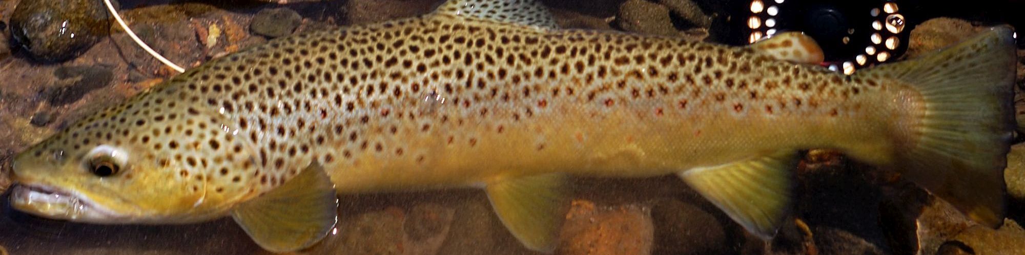
Lake Mackenzie was one of the first waters I fished in the early 80s. Back then spinning was always reliable around the windswept shores but the favoured methods included fishcakes and the good old wattle grub, both night-time activities. During this period superb condition three pound brownies were common.
In recent years the size has fallen off and numbers have probably increased, most fish now average around 700g with the odd one over a kilo. The rainbows all seem to be around the kilo mark. Mackenzie is managed as a western lakes fishery and has a bag limit of 5 which can include 2 over 500mm. It opens first Saturday in August and closes last Sunday in April. Mackenzie and Augusta are the two exceptions in the western lakes where bait fishing is still permitted along with artificial and fly.
Fishing methods and Lake description
A lap around the lake, either by foot or boat, reveals a number of different shores and fishing conditions although these change regularly with the ever fluctuating water levels. We will begin the lap of the lake at the first place reached, the 14 m high, 975 m long bitumen faced rock-filled dam. A parking area and convenient set of stairs exists near the dam near the outflow. Otherwise drive to the northern end and simply walk the dam’s length.
The dam wall itself may not seem like an attractive fishing location but armed with a fly rod and small dry fly, and coupled with suitable water level and weather conditions, it really is a magnificent venue.
Higher levels make for much easier casting and when the lake is minus eight metres or less some very tricky downward casting is required. By most afternoons in summer the prevailing westerly winds create a 1-2 m wide wind lane along most of the dam wall hard up against the face. Fish can be easily seen cruising the edge, each with their own designated beat, sipping insects from the calm surface. Simply walk slowly along the entire length of the dam with just your head over the guard rails. When a fish is spotted run ahead a few metres and lay a cast in front of the incoming quarry. Sounds easy but its amazing how many times a trout turns back on his beat just short of your fly. Casting directly down and in front of the fish spooks them more often than not.
On a suitable day seven to eight fish can be spotted off the wall. Lead each one back the way you have fished so as not to alert the rest. The fish that appear down a bit deeper and are cruising at a brisk walking pace will be rainbows, so cast well head. A fellow angling companion to spot for you and call the fish location on the wall is a real advantage.
Best locations on the wall are at either side of the intake structure and the extreme southern end. Remember, just your head above the guard rails or the game is up.
Moving anti-clockwise around the shore, the next one kilometre or so towards the Fisher River inflow is quite rough and rocky, and quickly drops away into deeper water. It is a reliable deep water spinning or soft plastic location, particularly in a strong northerly wind, and offers a good vantage point when spotting fish for the fly.
As you walk around into the bay the waters shallow out quickly, with water levels of about minus four and lower the entire bay becomes quite shallow and is mostly wadeable around the shoreline. There are however several very soft parts near the river inflow so tread with care. If the level is minus two metres or higher I would avoid this shore completely, as the water backs right up into bushes and makes progress very tough.
If you are hell-bent on getting to the Fisher River in such conditions there is actually a reasonably well-marked walking track which commences at the southern end of the cliff face near the dam. Once up through the scrub behind the cliff the track follows the edge of the moor and leads directly to the wire rope crossing on the Fisher River. This crossing marks the start of the Lake Explorer track and provides some hilarious entertainment for those unfortunate enough to get the crossing wrong. In high summer the river can be easily forded but if levels are high the wire crossing is essential.
Once the river is crossed the eastern side of the bay has some great shallows for polaroiding in summer. The bottom is a lot firmer than the western side but still has its moments. The next kilometre around the lake’s eastern side is very rocky and rough, recent day trips here have proved fruitless. However in the early days it was one of the best night-time fishing locations. This rocky eastern shore ends with a magnificent sandy beach that always has a couple of fish cruising within. It is the hotspot along this shore.
You are now roughly half way around the lake and depending on water levels have two large bays to contend with or a straight walk back to the dam. Levels of about minus seven separate both bays. The bays being shallow are good flyfishing locations and in perfect levels there are large amounts of shallow water suitable for polaroiding. Once levels fall too low however the wind invariably stirs up both bays and ruins the fishing.
Boating on Lake McKenzie is not popular but probably should be. Easy launching exists at the road’s end when boats can still be negotiated into Sandy Lake (NW Bay) the average depth is around 10 feet. This is a perfect depth in the bay for trolling, spinning and soft plastic fishing. On a recent trip we caught good numbers on the ever-reliable Rapala CD-7 and Berkley Black and gold T tail.
The next most reliable location was the entrance to the Fisher River bay. There are a number of hidden rocks, reefs and snags all around Mackenzie, and unless you’re familiar with the lake and its ever-changing levels I’d suggest very slow boating. By December onwards the lake has often been drawn down to typical summer levels of around minus eight and both bays will be exposed. A heavy rain in the Chudleigh Lakes can quickly refill the lake however and makes for great short-term fishing.
This year the lake was drawn down quickly to below -9 metres for repair work on the canal outflow. There was no where deeper than 15 ft across the lake. The lake has been slightly stirred up all year as a result but still clear enough to Polaroid. Experience has shown that the lake fishes very well in the last few weeks of April, particularly in slightly rough overcast weather. I intend to visit several times in this period.
The Chudleigh Lakes rate in my opinion as the best fly waters in Tasmania, and for years I have simply parked near Lake Mackenzie and walked in, occasionally looking back at the lake as I disappear over the escarpment. Recent years has seen me spending time at McKenzie first, or even just fishing it outright. Its popularity as a trout fishing destination has decreased markedly since the early 80s, but believe me if you make the time and explore the waters you will be surprised.
Associated Waters
Some waters nearby to McKenzie are also worth a mention in this article. Gun Lagoon lies about 2 km north of the main Fisher Dam water intake, which is just past the Devils Gullet turnoff. Park and cross the small bridge near the intake and follow the small creek across the open plain and up to the lake. It was stocked in the early 80s with rainbows, which apparently grew to around 8 pound. Today it supports a high population of one pound brownies.
On a suitable summer’s day Gun Lagoon has huge numbers of rising trout. The waters however become slight turbid making polaroiding difficult, so fish to the rises. Another nearby water is Yeates Lagoon, which lies in open moorland about 500 m north of where the Mackenzie canal is diverted underground. It can’t be seen from the road and if in doubt follow the small creek up that crosses the road. It is only about 200 metres across and mostly less than knee-deep.
At best it supports browns up to 4 pound, which can easily be polaroided. It is re-stocked from the creek, last year I waded all over it in perfect conditions and did not spot a fish, so I would only fish it occasionally with some time to kill.
The entire main canal right down to the intake is full of small browns which rise freely in summer. Anything over a pound here is huge, but I’ve always found it hard to drive past a rising trout no matter what the size.
Lake Balmoral is the nearest major western lakes water to Mackenzie lying just 15 minutes walk east from the sandy beach mentioned above. It supports a good population of browns slightly larger than found in Mackenzie. It can easily be included in a day trip around Mackenzie. The northern and western shores are the best spots. It is possible to wade out in the vicinity of the island and fish the drop off. Fish here this year were a bit lean.
Shane Flude