 REDMAP - The place to report uncommon fish and get prizes
REDMAP (Range Expansion Database and Mapping Project), is a new interactive website designed to collect data from the community about how climate change may be influencing the distribution of marine species in Tasmanian waters.Many species are undergoing range expansions or shifts in their distributional range, with those more often associated with waters around Victoria, South Australia and even New South Wales being more frequently caught or seen by local fishers and divers in Tasmania. There are also species that are usually present in the north of our state moving much further south. In fact, there is evidence to suggest that several dozen species have altered their usual geographical ranges over the last few decades.
Shifts in range for many of these species are thought to be a result of warming due to global climate change. Waters off the east coast of Tasmania are warming at 3–4 times the global average as this area gets a ‘double-whammy’ – the underlying warming that the rest of the ocean gets and an increased extension and persistence of the East Australian Current.
The database that forms the backbone of the REDMAP site will allow the local community to act as ‘citizen scientists’ and record scientific data by logging sightings of species that are caught or observed outside their usual or known range.
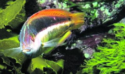
One of the species recently spotted on the east coast of Tasmania and logged on REDMAP is the grey morwong, also known as the blue morwong or great perch. This is a well-known New South Wales coastal reef species present from southern Queensland to Victoria. Adults are considered rare but present in the Bass Strait, around King Island. If you spot this species anywhere in Tasmania, please log your sighting on REDMAP.
Grey morwong spotted by a diver on the east coast of Tasmania. Photo by Tim Alexander
To check out the REDMAP website, log on to redmap.org.au and sign up as a user. Next, you may want to take a look at the species of interest. There is a list with photos of all the species REDMAP are currently interested in logging. You never know, something you have seen recently may be on the list. There is also the capacity for you to log sightings of species not on the REDMAP list, but that you know or suspect may be a species usually found further north.
If you do make a sighting, log it. There is a simple on-line form to fill out where all the data will be collected and sent to the REDMAP database. Sightings are divided into two categories: those with photos and those without. If you attach a photo to your data form, REDMAP can classify the data as ‘verified’ and the data is considered more robust. The location is recorded in a 50 km by 50 km radius – so we’re not giving away your favourite fishing spots! If you don’t have access to the internet you can still log your sighting – give us a call and we’ll post a form out to you.
While you are on the REDMAP website there is a lot to look at, particularly for school kids. There is Tasmanian-specific information about the importance of fishing to our state, the impact of climate change on the Tasmanian marine environment and information by Tasmanian scientists about their climate change work.
Log on to REDMAP, sign up as a member and receive our quarterly online newsletter. You will go in the draw to win monthly prizes including Mures vouchers, and if your friends sign-up too you could also win $400 Anaconda vouchers in February and March!
For further information, contact Fiona Brodribb, REDMAP Science Communication Officer on 62277267 (This email address is being protected from spambots. You need JavaScript enabled to view it.) or Dr Gretta Pecl on 62277243 (This email address is being protected from spambots. You need JavaScript enabled to view it.).