Lake King William
Although King William trout are small, many anglers find the high catch-rate to be very appealing. The lake is also one of the few trout waters open to year-round sport, though fishing in winter can hardly be recommended.
The lake has been very low for the past couple of years but at the time of writing (mid September) the water was rising quickly and it seemed likely that high levels would be maintained for at least a couple of months. Consequently, anglers can expect better than average fishing during the lead up to Christmas.
Description
Lake King William, impounded behind the 67 m high Clark Dam, is part of the Tarraleah Power Development. Full supply is 719.94 m above sea level but the normal operating range is a whopping 29 m so the size and shape of the lake are quite variable. Even if the impoundment has reached its normal minimum operating level, it may refill in a single season.
Substantial eucalypt forests fringe the high banks along the eastern and southern shores, and between the Guelph Basin and the main lake. Although the littoral zones adjacent to these areas have eroded back to bedrock and clay, they still support significant stands of drowned trees.
Vast buttongrass plains extend from the north-western shores and around the Guelph Basin. In these areas, low water results in the exposure of vast mud flats.
Trout stocks
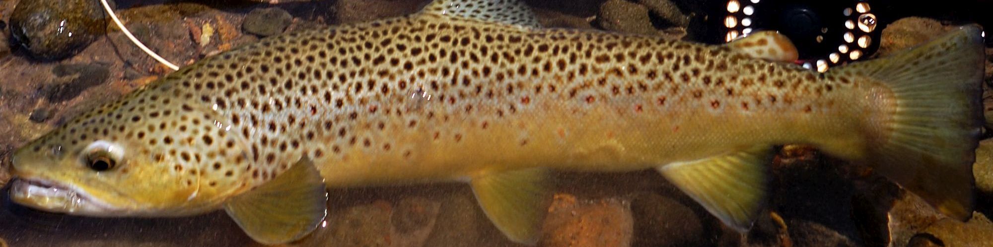
The fishery is maintained entirely by natural recruitment, the main spawning areas being the upper Derwent, the Navarre River, the Little Navarre River, the Guelph River, the Middle River and Rufus Rivulet. Brown trout dominate, though rainbows account for about 5 % of the annual harvest. Most fish are very small (0.2-0.5 kg) but when the lake rises over long-exposed flood plains foraging browns quickly gain weight and condition, commonly attaining 0.7 kg or so. At almost four trout per angler per day, the average catch rate is the highest recorded in the Central Highlands.
History
The Tarraleah Power Development was approved by Parliament in 1934 and by 1937 dams, pumps and control gates had been constructed at Lake St Clair. At the same time a small weir was erected on the River Derwent at Butlers Gorge to enable water to be diverted via a series of flumes canals and pipelines to the Tarraleah Power Station in the Nive valley. The power station was commissioned in 1938.
Further expansion of the Tarraleah project began at the end of the Second World War, and by 1949 the small weir at Butlers Gorge had been superseded by the 61m high Clark Dam.
There were sufficient trout already in the natural river system to guarantee both instant sport and continued natural recruitment. However, during the last few months of 1949 some 22 000 brown trout yearlings and 76 000 rainbow trout yearlings were liberated into the rising waters of the new impoundment. Extensive stocking of the lake continued for several years.
During 1951 the lake (almost) filled and the fish reached an average of about 3lb. In the following few years many fish to 7lb were taken. From the outset limit bags were common and the fishery remained very popular for about a decade. However, by the 1960s the relative abundance of rainbows had declined and the average weight of the brown trout had fallen below 2lb.
By the standards set at other new impoundments, average trout were never large. This can be attributed to the tremendous number of fish and the fluctuating water levels. A less-zealous stocking programme may have been beneficial in the early years but by the mid 1950s enormous stocks of trout were being maintained solely through natural recruitment.
In 1966 the Clark Dam was raised by 6 m to a new height of 67 m, though the new full-supply level was not reached until several years later.
Fly fishing
Flood-plain fishing
Some of the best fishing occurs when the lake is refilling after having been drained very low. These conditions are most likely to occur during spring.
You need to seek out sheltered basins rather than steep banks, the hot spots being the bays fringing the Guelph Basin, the Navarre arm and the small bay adjacent to the Lyell Highway just west of the River Derwent inlet.
Ideally the water will be inching up over extensive beds of amphibious weeds and/or terrestrial regrowth. The fishing is not so good when the water is so high that it has broken out into the permanent buttongrass and/or reached the steeper banks which bound some of the smaller flats. Ideal levels range from about minus 5 m to about minus 1.5 m.
If the water has been low for part of one year, the fish feed mainly on aquatic insects, crustaceans and snails as well as a few drowned spiders and terrestrial insects. If you are lucky you might even find worthwhile numbers of frogs.
If the lake has been low for successive seasons, allowing time for worms and grubs to recolonise the flats, rising water flushes out a wealth of forage food and the brown trout tend to pile on weight.
You often find brown trout tailing along the edges but polaroiding the weedy flats is a reliable fall-back.
Polaroiding
Spotting from the steeper banks is only worthwhile when the fish are rising and even then the small size of the fish can make them relatively difficult to track.
There is reasonable scope for wade-polaroiding over the flats when the lake is moderately high but when the water falls below the weed-beds you are apt to get bogged in thick black mud.
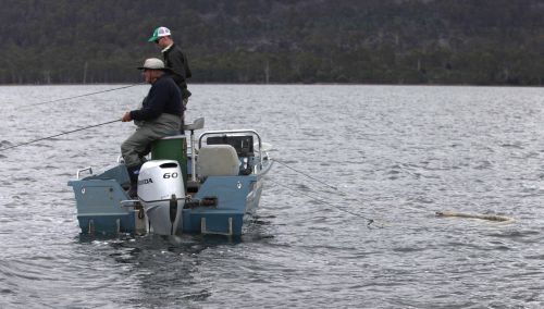
The most efficient way to fish is to polaroid from a boat, concentrating your efforts on the weed-beds or black mud in the shallow bays where it is common to spot clusters of three to 12 fish swimming in sync like homing pigeons. The wind-lanes are also worthy of inspection, particularly when midges or beetles are about.
Rising Fish
Consistent dry-fly fishing is available on warm settled days with good rises to beetles, caddis flies and other insects. The shallow bays in the Guelph Basin, the south-western shore of the main lake, and the western fringes of the northern end of the lake are very good, though rises can occur anywhere.
Mudeyes feature among the drowned trees and sticks during summer and early autumn.
Reasonable wind-lanes form in open water where fish can be found feeding on midges and beetles. These areas are dominated by brown trout but still provide the best chance of catching a few rainbows.
Blind fishing
If trout are not moving, good results can be achieved by blind casting with nymphs and small wets, though these days most proficient anglers prefer to use a team of three dry flies in the classic English loch style. The hot spots are the shallow bays and the fringes of drowned trees and scrub.
Winter fishing
At this time of year anglers can expect to encounter bitter winds, freezing rain and/or snow while the lake itself is usually at its lowest ebb. Consequently the fishing is generally unappealing, though dedicated locals achieve a degree of success, mostly with wet flies and lures.
The brown trout begin congregating to spawn in April/May and by June/July there are plenty of hungry post-spawners near the (inflowing) River Derwent and around the mouths of tributary creeks in the Guelph Basin and Navarre Bay. (There is no 50 m exclusion buffer around the stream-mouths but the streams themselves remain closed to angling from the end of April until the beginning of August.)
Other fish, mainly maiden brown trout, continue to feed in the shallow bays though in the face of cold weather their activity is substantially subdued.
Lure fishing
Spinning from the shore
Convenient shore-based spinning is largely confined to steeper banks (such as those near the dam) while the biggest concentrations of fish are commonly found around the fringes of shallow basins. Although these flats can be effectively fished with shallow-running lures, boggy silt can make fishing from the shore quite unpleasant and most serious anglers opt to fish from a boat.
Spinning from a boat
Lure casting from a drifting boat is extremely effective, especially when fishing over boggy flats or amongst drowned trees and scrub.
Trolling
By far the majority of fish taken in King William are caught by trolling with Cobras and Devons. Undoubtedly the best areas are the Guelph Basin and the northern end of the lake. Most anglers prefer to troll close to the shores but good catches can be made anywhere. Limit bags are common even on bright days.
Winter fishing
Winter fishing is essentially the same for lure fishers as it is for fly fishers (see above).
Bait fishing
Cast-and-retrieve surface fishing with grubs in the evening is a deadly method. Otherwise it is worthwhile set-rod fishing with worms, mudeyes or grubs.
Special Regulations
In light of Lake King William being overpopulated with brown trout, the fishery is subject to lenient regulations. Anglers are able to fish year-round and to keep a generous bag of 20 fish per day. There is no 50 m exclusion buffer around the mouths of spawning streams but inflowing rivers and creeks are subject to the normal closed season (from the end of April until the beginning of August).
Access
Normally the most convenient access is via the unsealed Butlers Gorge Road to the Clark Dam at the southern end of the lake.
When levels are high, the northern end of the lake can be reached from the Lyell Highway near Derwent Bridge. However, the storage is often well below full supply and can recede kilometres down the old river course.
A rough 2WD track extends south from the Lyell Highway (10km west of Derwent Bridge) to the Guelph Basin.
Rugged 4WD tracks extend from the Lyell Highway to Navarre Bay, and along the eastern banks (north from Butlers Gorge).
Boat ramps
A substantial launching ramp exists at the southern end near the Clark Dam.
When the lake is full, boats can be launched near the Derwent inflow but at low levels boat access from the north is almost impossible.
Camping
Informal lakeshore camping is permitted. The most attractive camping is at the Guelph basin. At the southern end there are a few unappealing sites near the boat launching ramp and along the 4WD track. Other sites can be found at Navarre Bay.
Accommodation
There are no formal facilities at the southern end on the lake so anglers have access to convenient accommodation and shops only when fishing from the northern end (an appealing option only when levels are moderately high).
The Derwent Bridge Chalets are six fully self-contained holiday units located beside the Lyell Highway at Derwent Bridge, a few kilometres east of Lake King William (phone 03 6289 1000; www.troutwalks.com.au; email This email address is being protected from spambots. You need JavaScript enabled to view it.).
Also at Derwent Bridge is the Derwent Bridge Wilderness Hotel which offers a range of accommodation (phone 03 6289 1144).
Five kilometres further away at Lake St Clair (inside the national park) is Lakeside St Clair which again provides a range of accommodation services (phone 03 6289 1137).
Shops
There is a roadhouse at Derwent Bridge and a kiosk at Lake St Clair, both of which supply basic groceries.
Petrol is available from the roadhouse.
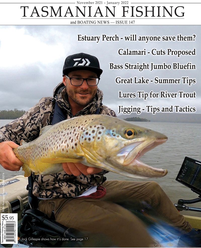
Greg French